This is an old version of documentation. You are welcome to visit our new help center. Open.
Extended Unit Information
To view extended information about a unit, tap the line with it in the list.
The information is shown on two tabs:
- Info;
- History.
The contents of the tabs can be divided into four blocks:
- map;
- latest data about the unit;
- general information about the unit (the Info tab);
- data on trips, parkings, fuel fillings, and thefts (the History tab).
You can hide the map or the general information/data block. To do this, drag the latest data block up or down respectively. You can also use the arrows on the right side of the latest data block.
In the upper right corner of the screen, there is the icon ![]() . Tap it to open the additional menu with the options.
. Tap it to open the additional menu with the options.
Info
The Info tab shows the information about the unit and its position on the map (taken from the last message).
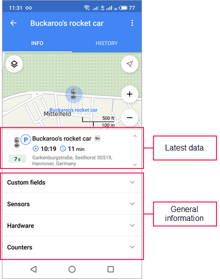
In the General information block, you can view such unit properties as custom fields, sensors, hardware, counters, parameters ('raw' data from the equipment), drivers, trailers, altitude, and number of satellites.
You cannot edit unit properties in the application. After a long tap on the line with the property, its value is copied to the clipboard.
The access rights required to view the unit properties:
✧ View custom fields;
✧ View admin fields;
✧ View drivers;
✧ View trailers.
History
The application uses the data obtained as a result of real-time processing of messages.
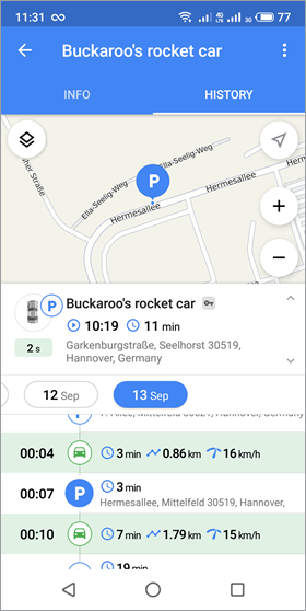
The History tab displays a list which contains data on trips, parkings, fuel fillings, and thefts.
The Wialon app uses the trip detection settings with such methods of motion detection as GPS speed, GPS coordinates, and Engine ignition sensor. When detecting movement by GPS speed and GPS coordinates, the parameters of the Allow GPS correction option are always applied.
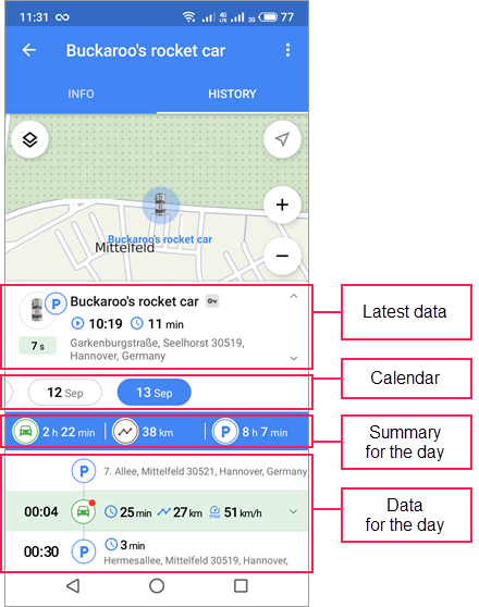
The data on the tab is presented in chronological order and is formed on the basis of the messages received in the last 24 hours. The data is not formed on the basis of the messages generated more than 24 hours ago (after they are unloaded from the black box).
By default, the data is displayed for the current day. You can get the data for another day in one of the ways described below.
- Select the required day in the calendar.
- Swipe down or up to add the previous or next day to the list. If necessary, repeat the action to add more days.
For each day, the summary of the trip duration, track length, and the total parking time is shown above the list.
Below is the information displayed for each type of data.
![]() Trip:
Trip:
- the start time of the trip;
- duration (
 );
); - track length (
 );
); - maximum unit speed (
 );
); - speeding (
 : the unit has exceeded the speed limit,
  : speed limit indicated on the Advanced tab of the unit properties in the web version of Wialon);
 - fuel consumed during the trip (
 ): its amount (
  ) and average consumption per 100 km (
  ) or miles per gallon (
  ) for U.S. and imperial measurement systems.
The amount of fuel consumed during the trip is determined by the fuel level sensor (FLS). If there are several sensors, the sum of their values is displayed. The amount of fuel in the application may differ slightly from the resulting data in the reports executed in the web version of Wialon. This may be due to the fluctuations of the FLS analog data, particularities of division into intervals, and the use of grouping in reports.
![]() Parking:
Parking:
- the start time of the parking;
- duration ();
- parking time with ignition on (
 );
); - location.
The information about ignition is available if the unit has an ignition sensor installed.
![]() Ignition:
Ignition:
- sensor name;
- the time of turning the ignition on;
- the time that has passed since the ignition was turned on ().
This information is displayed if the unit had the ignition on according to the sensor, but there was no trip detected.
![]() Fuel filling:
Fuel filling:
- the time of the fuel filling (time of the greatest difference in fuel level);
- the amount of filled fuel ();
- location.
![]() Fuel theft:
Fuel theft:
- the time of the fuel theft (time of the greatest difference in fuel level);
- the amount of drained fuel ();
- location.
To see the track of the trip, the place of speeding, parking, fuel filling or theft on the map, tap the corresponding line in the list.